Many will remember the dicey spring days in Trail before 1969, when high river water was a real and serious threat on both sides of the river.
The disastrous flood of 1948 that impacted much of the province was followed thirteen years later by another major river event in Trail.
In May and June of 1961, the Trail Daily Times, much like in 1948, was thorough in reporting water levels upstream: specifically at Revelstoke and Castlegar. With the Kootenay River pouring into the Columbia at Castlegar, those levels were also monitored closely.
In early June, city officials were careful to avoid fuelling any residual fear from the previous flood.
While acknowledging that levels would likely reach those of June 1948, civil defence made regular announcements assuring residents that human safety was never in peril.
Waters certainly did impact Trail, particularly along Groutage and Bay Avenues.
There was, however, a general confidence in early June 1961 that the devastation experienced in 1948 would not be repeated, as the river wall had been built up and fortified following that earlier event.
In fact, by June 10, 1961, the paper declared the flood threat to be over.
The water never did reach the 1948 level of 46.17 feet, cresting instead at 45.1 feet on June 13.
However, on June 23, 1961, a 150-foot portion of the river wall was shockingly breached, as water levels took a considerable amount of time to recede.
The collapse caused a large, current-heavy pool to form inward, and a huge portion of the Esplanade disappeared into the river.
The edge of the whirling water nearly reached the Merry Lumber Co., located at the corner of Spokane Street and the Esplanade.
Had the wall collapsed at the river’s peak, it’s likely the building would have been lost.
Also swept away was a vehicle owned by Miss Betty McCormick, who worked in research and development at Cominco.
The clean-up process was just as tedious, especially for low-lying properties downtown.
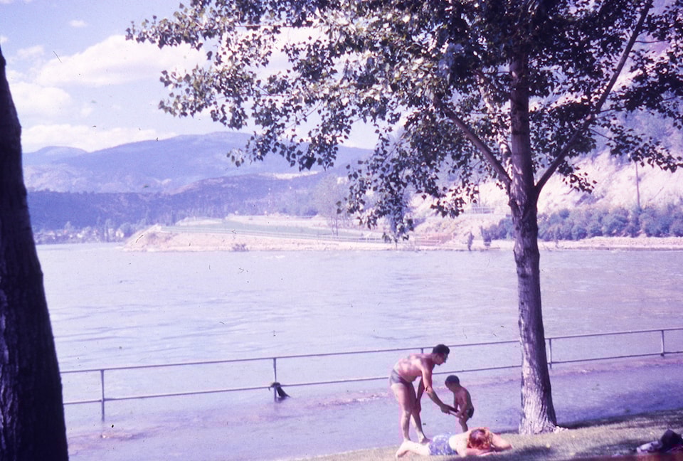
This photo, what should be Gyro Beach, is a unique view of the water levels on June 25, 1961.
The river reached the sidewalk above the beach and completely covered “The Onions.”
The grassy area in the distance is near the pull-out along Charles Lakes Drive.
We are fortunate to have protection from this dangerous threat today.
Hydro-electric development would begin soon after this event, as the Columbia River Treaty had been negotiated and signed in January 1961, and ratified in 1964.
The Hugh Keenleyside Dam, or High Arrow, was operational by October 1968.
Trail is likely the one distinct community benefiting entirely from the dams, where many other communities, cultures, and First Nations, both upstream and down, experienced anguish and tremendous loss.
Sarah Benson-Lord, manager, Trail Museum and Archives and Visitor Centre.


