
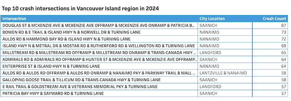
Saanich lays dubious claim to the top crash intersection on Vancouver Island, according to 2024 data from ICBC.
The agency updated its data for last year on vehicle-related crashes and injuries, auto crime, vehicle population, driver licences, and tickets.
The intersection where Douglas Street meets McKenzie Avenue and the adjacent on and off ramps with the Pat Bay Highway saw 87 reported crashes at intersections.
Nanaimo intersections claimed the No. 2 and 3 positions – Bowen Road the E&N Trail/Island Highway and Norwell Drive saw 73 crashes, while Aulds Road at Hammond Bay and the Island Highway was just shy of that at 72.
On Vancouver Island, 5,365 people were injured in 11,612 reported crashes last year, more crashes than the year before and higher than the five-year average of 10,399.
Saanich, the largest geographic region in the South Island, saw 64 crashes at Admirals Road and the Highway 1 off and on ramps there, and 58 at the Galloping Goose, Tillicum Road and Trans-Canada Highway intersection.
In Victoria, the top crash intersection of Douglas at Gorge and Government streets tops the charts with 48 crashes last year. Douglas at Finlayson tallied 42 and Bay Street at Blanshard saw 41 (with the Blanshard intersection at Hillside just behind at 40).
Just at the border with Oak Bay, and falling in that district’s statistics, Cadboro Bay Road, where it becomes Fort, and Foul Bay saw 20 crashes last year. Foul Bay at Oak Bay Avenue saw 16.
Regular commuters may not be surprised to find Langford, a fast-growing community with high traffic rates, saw where Millstream meets the TCH atop its list of crash intersections with 65 last year.
The E&N Rail Trail/Goldstream Avenue and Veterans Memorial Parkway intersection witnessed 57 crashes and the Galloping Goose Trail/Kelly Road/Veterans Memorial tallied 42.
Colwood’s claim to fame is where the Galloping Goose Trail, Island Highway, Ocean Boulevard and Wale Road intersect, with 51 crashes reported there in 2024. The next highest is Goldstream Avenue at Island Highway and Sooke Road at 29.
The complex intersection of the Galloping Goose/Helmcken/Hospital Way/TCH in View Royal saw 52 crashes reported last year.
The top crash site in Esquimalt was Craigflower at Tillicum with 38.
Millstream takes the blame in Highlands too, with five crashes reported at Millstream Lake Road and Millstream Road.
While the Saanich intersection with Highway 17, or the Pat Bay Highway, claims top spot for the Island, where it meets in Sidney tops that town’s intersection crash rate for last year at 53. That’s well ahead of Sidney’s next highest crash site, with 13 reported at Beacon Avenue and Seventh Street.
The smaller communities with fewer intersections were not without crashes. In North Saanich, Lochside Trail at McDonald Park Road notched 13 reported crashes in 2024, while McTavish and the Pat Bay Highway saw 11 and the nearby Canora at McTavish, 9.
Out Sooke way, the Derbend Road/Edward Milne Road/Sooke River roads saw 19 crashes last year. Church at Goodmere and Sooke tied with Sooke and Woodlands roads with 13 crashes each.
In Metchosin, Kangaroo Road and Sooke Road topped out with eight reported crashes.
The June 2 data update is the first of two scheduled for the year. In the fall, 2024 information on fatalities and police-reported crashes will be published after a data reconciliation process between ICBC, BC Coroner’s Service, BC RCMP, and RoadSafetyBC.


